Cape Agulhas: The Southernmost Tip of Africa and Its Maritime History
Explore Cape Agulhas, where the Indian and Atlantic Oceans officially meet at Africa's southernmost point. Discover its legendary lighthouse, historic shipwrecks, and 500 years of maritime history.
Cape Agulhas (34°50′S, 20°00′E) is the geographic southernmost point of the African continent and the official dividing line between the Indian and Atlantic Oceans, set by the 20° east meridian. But it is far more than a map reference: this rugged coast is steeped in tales of shipwrecks, castaways and phantoms. Around the year 1500, Portuguese navigators noticed that here their compass needle pointed to true north, with no deviation from magnetic north, and named the point ‘Cabo das Agulhas’, the Cape of Needles[1]. Today a monument and a large stone map of Africa mark the exact spot, and Cape Agulhas still draws explorers with its aura of mystery and adventure.
These treacherous waters have claimed countless ships journeying east past Cape Agulhas. Known for its hazardous conditions, the cape endures fierce winter storms and towering swells, with rare rogue waves reported up to 30m high. Here the warm Agulhas Current, sweeping down Africa’s east coast, meets the cold water and gale-force ‘Roaring Forties’ winds of the Southern Ocean, and together with the shallow reefs of the Agulhas Bank this creates perilous conditions, earning the bank its grim nickname, the ‘Graveyard of Ships’. The coastline is scattered with wrecks, among them the Zoetendal (1673) and the Arniston (1815), as well as the famous Birkenhead (1852), which went down off Danger Point near Gansbaai further along the Overberg coast. While little treasure has been recovered from these wrecks, many artefacts are displayed at the Bredasdorp Shipwreck Museum. Visitors can still see the rusted bow of the Meisho Maru No. 38, a Japanese trawler that ran aground in 1982 with all 17 crew rescued[2].
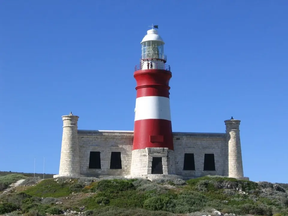
Completed in 1848 and first lit on 1 March 1849[3], the Cape Agulhas Lighthouse was built to warn ships of the treacherous currents and waves. This red-and-white striped tower, the second-oldest working lighthouse in southern Africa (after Green Point in Cape Town)[4], is now a national monument and houses the only lighthouse museum in Africa. Among its exhibits are ancient stone fish traps once used by the Khoikhoi thousands of years ago. Climbing the 71 steps to the top rewards visitors with a stunning view of the wild ocean.
The Agulhas Plain is home to an extraordinary diversity of flora, with more than 2,000 plant species[5], including the distinctive limestone fynbos and many plants found nowhere else on Earth. It forms part of the Cape Floristic Region, a UNESCO World Heritage Site and one of the world’s six floral kingdoms, which boasts some 9,000 plant species in total. The region, taking in the towns of Arniston, Bredasdorp, L’Agulhas, Napier, Elim and Struisbaai, draws visitors with its many attractions. The Agulhas Bank offshore is one of South Africa’s richest fishing grounds, where locals catch yellowtail, kabeljou, Cape salmon, red roman, stumpnose and mussel cracker, depending on the season.
Struisbaai boasts roughly 14km of pristine sand, said to be the longest natural beach in the Southern Hemisphere[6], along with warm Indian Ocean swimming and excellent walking and fishing. The village’s original thatched fishermen’s cottages are close by, and visitors can enjoy 4x4 beach safaris, nature reserves, hikes and horse rides.
From June to November the area is a hotspot for whale watching, with Southern Right, Humpback and Bryde’s whales frequenting the coastline. The African black oystercatcher is protected along many of the beaches. Dolphins, porpoises, Cape Fur seals, and a variety of birdlife, tortoises and smaller mammals such as caracal can also be spotted.
This ruggedly beautiful coastal plain at the southernmost tip of Africa, rich in cultural and natural heritage, was proclaimed the Agulhas National Park in 1999[7]. Lying about 220km (a roughly two-and-a-half-hour drive) southeast of Cape Town via Bredasdorp, it makes a rewarding day trip or relaxed weekend escape.
Other vessels lost along this coastline include the Queen of the Thames (1871), the European (1877), the Elise (1879), the Cooranga (1964), the Gwendola (1968) and the Federal Lakes (1975).
Sources
- Cape Agulhas, Wikipedia
- The Wreck of the Meisho Maru No. 38, Atlas Obscura
- The Cape Agulhas lighthouse begins operating, South African History Online
- Cape Agulhas Lighthouse, Wikipedia
- Vegetation, Agulhas National Park, SANParks
- Struisbaai, Whales and More
- Agulhas National Park, Wikipedia
What do you think?
Join the conversation on our South African community forum. Share your perspective, ask a question, or just say hello.